
Very Severe Cyclonic Storm Arnab is moving towards the Andhra Pradesh coast over the west-central Bay of Bengal, prompting high alerts, evacuations and extensive disaster preparedness across eastern India. According to the India Meteorological Department (IMD), the storm is expected to cross the Andhra Pradesh and Yanam coasts near the stretch between Bapatla and Visakhapatnam during the early hours of October 28, 2026.
As of October 27, authorities are preparing for destructive winds, heavy to extremely heavy rainfall, rough seas and possible disruption to road, rail and air transport. The storm is also expected to influence weather conditions in Odisha, West Bengal and neighbouring inland states.
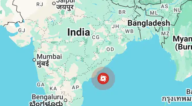
Cyclone Arnab Latest Update: October 27, 2026
In its evening bulletin issued at 9:18 pm IST on October 27, the IMD reported that Very Severe Cyclonic Storm Arnab was moving west-northwestwards at approximately 18 kmph.
At 5:30 pm IST, the storm was located over the west-central Bay of Bengal, off the Andhra Pradesh coast, approximately 90 km southeast of Kakinada, 170 km south-southwest of Visakhapatnam and 240 km east-northeast of Bapatla.
The IMD forecast that the cyclone would move towards the coast and cross near the south of Yanam during the early hours of October 28. Maximum sustained wind speeds were forecast at 125–135 kmph, with gusts reaching up to 150 kmph. These figures represent the forecast intensity at landfall, not a confirmation of the eventual conditions.
Source: India Meteorological Department’s coastal weather bulletin.
What Is Very Severe Cyclonic Storm Arnab?
A very severe cyclonic storm is a high-intensity tropical cyclone capable of causing significant damage through strong winds, intense rainfall, flooding and dangerous coastal conditions.
The storm developed over the Bay of Bengal after an earlier low-pressure system intensified into a depression and subsequently a cyclonic storm. It strengthened further as it moved towards India’s eastern coastline.
The name Arnab is pronounced “Ornab”, according to the IMD bulletin. The storm’s classification reflects its intensity, while its actual impacts will depend on its track, wind field, rainfall distribution and local geographical conditions.
Expected Landfall and Cyclone Track
The IMD’s forecast as of October 27 indicates that Cyclone Arnab is expected to cross the Andhra Pradesh and Yanam coasts between Bapatla and Visakhapatnam, close to the south of Yanam.
The projected landfall period is the early hours of Wednesday, October 28. The cyclone’s movement and intensity may change, so residents should follow updated official forecasts rather than relying solely on earlier projections.
Coastal areas near Kakinada, Visakhapatnam, Machilipatnam, Bapatla and adjoining vulnerable locations are among the areas requiring particular attention to official warnings and evacuation instructions.
Wind Speed and Rainfall Forecast
The cyclone poses multiple weather-related risks.
- Strong winds: The IMD forecast sustained winds of 125–135 kmph at landfall, with gusts up to 150 kmph.
- Heavy rainfall: Coastal Andhra Pradesh and southern Odisha face the risk of heavy to extremely heavy rainfall in some locations.
- Flooding and waterlogging: Intense rainfall could overwhelm drainage systems and cause flooding in low-lying areas.
- Rough seas: Coastal waters are expected to remain dangerous, with fishing and other maritime activities restricted.
- Damage to infrastructure: Strong winds may damage weak structures, uproot trees, disrupt power supplies and affect transport.
The IMD’s October 27 coastal bulletin also reported very rough to high sea conditions along the southern Odisha coast, with local cautionary signals maintained at Odisha ports.
States Likely to Be Affected by Cyclone Arnab
Andhra Pradesh
Andhra Pradesh is at the centre of the immediate landfall threat. Authorities have placed vulnerable districts on high alert, arranged evacuations and deployed emergency response personnel.
According to a report published by Rediff on October 27, the state had prepared cyclone shelters, medical teams, emergency beds and ambulances. More than 1,300 pregnant women had been moved to hospitals as a precaution, while authorities were also working to ensure essential supplies and emergency communication.
Odisha
Southern Odisha is expected to experience heavy to extremely heavy rainfall in some areas, along with strong winds and rough seas. The state’s administration has prepared shelters, mobilised response teams and taken precautionary measures in vulnerable districts.
The effects may extend beyond coastal areas, with intense rainfall potentially causing waterlogging and flooding in inland locations.
West Bengal
The IMD has forecast rainfall across parts of West Bengal from October 27 to 30. South 24 Parganas, Purba Medinipur, Paschim Medinipur, Jhargram, Bankura and Purulia are among the districts facing a risk of heavy rainfall during this period.
Heavy rain is also forecast in parts of the sub-Himalayan region, including Darjeeling, Kalimpong, Alipurduar and Jalpaiguri, on October 29 and 30.
Source: DD News report on the West Bengal rainfall forecast.
Other Inland States
The storm’s wider weather effects may extend into Telangana, Chhattisgarh, Jharkhand and other regions. Rainfall, thunderstorms, gusty winds and localised flooding are possible depending on the cyclone’s movement and subsequent weakening.
Residents should consult their local meteorological centre for district-specific forecasts.
Evacuations, Flight Cancellations and Train Disruptions
Authorities are taking precautionary measures to reduce the risk to life and property. These include moving residents from vulnerable coastal settlements, preparing relief shelters, deploying disaster response teams and restricting access to dangerous beaches and coastal roads.
A report published by Rediff on October 27 stated that at least 50 trains had been cancelled in the region and at least 21 flights at Vijayawada and Visakhapatnam airports had been cancelled on Tuesday. Additional cancellations were announced for Wednesday.
Travellers should check the latest status directly with their airline, railway operator or airport before starting their journey, as schedules may change at short notice.
Safety Guidelines for People in Cyclone-Prone Areas
Residents in affected areas should take official warnings seriously and prepare before conditions deteriorate.
- Follow evacuation instructions issued by district administrations and move to designated shelters when directed.
- Stay indoors and away from windows during strong winds. Avoid damaged buildings, loose structures and exposed coastal areas.
- Keep drinking water, essential medicines, a torch, charged power banks, identification documents and basic emergency supplies ready.
- Avoid flooded roads, overflowing streams, fallen power lines and unnecessary travel during severe weather.
- Fishermen should follow official restrictions and avoid venturing into the sea.
- Keep phones charged and monitor updates from the IMD, state disaster management authorities and local administration.
- Do not spread unverified cyclone forecasts, videos or evacuation claims on social media.
For official information, consult the India Meteorological Department and the relevant state disaster management authority.
Very Severe Cyclonic Storm Arnab is approaching India’s eastern coastline, with landfall forecast near the Andhra Pradesh and Yanam coasts during the early hours of October 28, 2026. The IMD’s latest evening bulletin forecasts sustained winds of 125–135 kmph, with gusts reaching 150 kmph, alongside heavy rainfall and dangerous coastal conditions.
Preparedness, timely evacuation and adherence to official warnings will be essential to reduce the storm’s potential impact. The cyclone’s track, intensity and rainfall distribution may change, making updated official advisories particularly important through the landfall period.
Last updated: October 27, 2026. Forecasts and transport information may change as new bulletins are issued.